Your all-in-one marine forecast dashboard
Stop checking multiple apps. Get your tides, wind and wave conditions, barometric pressure and more in one clean dashboard.
All-in-One Dashboard
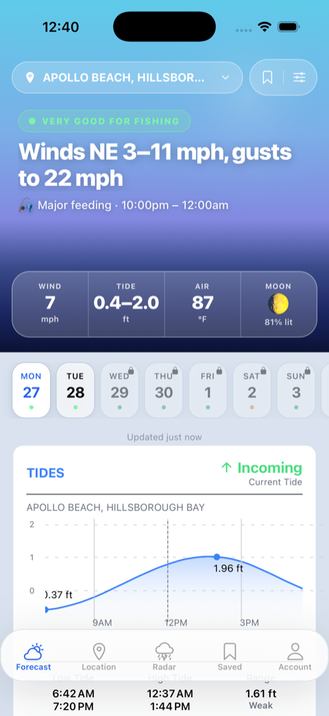
Wind speed and gusts, tide predictions, air temperature, precipitation, barometric pressure, wave conditions, sun and moon data — all on one screen.
Compare Weather Models
See when GFS, ECMWF, HRRR, and NAM models agree or diverge. When all four align, plan with confidence.
7-Day Marine Forecast
Plan ahead with extended marine forecasts. See how conditions change day by day so you can pick the perfect window.
Take it on the water
The My Marine Forecast iOS app puts your forecast in your pocket — live weather radar, solunar fish feeding windows, and tides, wind, and waves for your saved spots.

Marine Forecasts by Location
Browse free marine forecasts with real-time tide predictions, wind conditions, and fishing data for popular coastal destinations.
Florida
Texas
Louisiana
South Carolina
North Carolina
Alabama
Mississippi
Virginia
Maryland
Delaware
Rhode Island
Massachusetts
New Hampshire
Maine
Fishing Tips & Marine Weather Guides
How Spring Weather Creates New Structure Fishing Opportunities
Learn how spring weather patterns create new fishing opportunities around structure. Understand how warming water, changing currents and seasonal baitfish movements open up structure that was dead all winter.
How to Read Water Color Changes in Spring for Better Fishing
Learn how to read changing water color in spring to find more fish. Understand what causes water color changes, how different colors affect fish behavior and where to find the best fishing when water clarity shifts with weather patterns.
How Spring Water Temperature Changes Create New Fishing Opportunities
Learn how rising water temperatures in spring trigger feeding activity, open new fishing areas and create short-term opportunities that disappear quickly. Understand when and where to fish as water warms from winter to spring patterns.
How to Set Up Custom Weather Alerts for Your Home Waters
Learn how to create custom weather alerts tailored to your local fishing spots. Understand which conditions to monitor, how to set up alerts through apps and NOAA Weather Radio, and build a notification system that actually helps you catch more fish.
Best Marine Weather Apps for Offshore: 5 Compared (2026)
PredictWind, Windy, Fishweather, NOAA Weather Radar and SailGRIB compared for offshore fishing and boating: which keep working with no cell service, which give you GRIB files and multi-model forecasts, and which one to pick for the way you actually run.
Night Fishing Safety: Weather Factors You Can't See
Learn how to stay safe night fishing when you can't see approaching weather. Understand invisible dangers like fog, wind shifts, lightning and how to monitor conditions that change after dark using technology and your senses.
Frequently Asked Questions
- What is My Marine Forecast?
- My Marine Forecast is a marine weather and fishing-conditions app for anglers and boaters. It combines tides, wind, waves, water and air temperature, barometric pressure, and solunar fish-feeding windows into a single dashboard for coastal locations from Texas to Maine.
- Where does the forecast data come from?
- Tide predictions and water temperature come from NOAA CO-OPS Tides & Currents; wind and weather forecasts from the NOAA National Weather Service; and multi-model forecasts (GFS, ECMWF, HRRR, NAM) from Open-Meteo. Fish feeding windows are calculated from solunar theory using sun and moon position.
- What areas does it cover?
- More than 90 coastal cities across 16 states, from Texas and the Gulf Coast up through Florida and the Southeast Atlantic to the Mid-Atlantic and New England.
- Is My Marine Forecast free?
- Yes — city forecast pages with today's conditions are free and require no account. A Pro subscription unlocks extended forecasts and advanced tools.
- What does Pro include and how much does it cost?
- Pro is $4.99/month or $45/year with a 7-day free trial, and you can cancel anytime. It unlocks 7-day extended forecasts, multi-model comparison (GFS, ECMWF, HRRR, NAM), a customizable dashboard, and unlimited saved locations. One account works on both web and iOS.
- Is there an iPhone app?
- Yes. My Marine Forecast is available on the Apple App Store. It adds live weather radar and solunar fish-feeding windows alongside tides, wind, and waves, and uses the same account as the web app.
- What are solunar fish-feeding times?
- Solunar theory predicts periods when fish are most active based on the position of the sun and moon. My Marine Forecast highlights major and minor feeding windows for each day so you can time your trip.
- How often is the data updated?
- Forecast data is updated hourly from NOAA and Open-Meteo sources.